April 28, 2011
Japan Agency for MarineEarth Science and Technology
Evidence of Tsunami Generating Seismic Rupture
- Indicated by Cores from NanTroSEIZE Expedition by D/V CHIKYU -
Introduction
An international group of researchers led by the Japan Agency for Marine-Earth Science and Technology and The University of Tokyo, has discovered evidence of seismic slip in core samples recovered from the uppermost portion of the megasplay fault in the Nankai Trough. Scientists have long believed the possible involvement of the seismic slip at the updip end (overriding end) of the fault in the trigger of tsunami. The findings of this study have provided, for the first time, evidence to support this theory.
The cores were obtained during the IODP Nankai Trough Seismogenic Zone Experiment (NanTroSEIZE): Stage 1 Expedition 316, conducted in 2009.
Their work was published in the April issue of the journal Geology.
- Title:
- Seismic slip propagation to the updip end of plate boundary subduction interface faults: Vitrinite reflectance geothermometry on Integrated Ocean Drilling Program NanTroSEIZE cores
- Authors:
- Arito Sakaguchi, Frederick Chester, Daniel Curewitz, Olivier Fabbri, David Goldsby, Gaku Kimura, Chun-Feng Li, Yuka Masaki, Elizabeth J, Screaton, Akito Tsutsumi, Kantaro, Ujiie, Asuka Yamaguchi
Background
In the Kumano Basin, off the coast of the Kii Peninsula, the Philippine Sea plate subducts beneath the Japanese archipelago. Along the subduction zone, sediments are scraped off the downgoing plate and form an accumulation of sediment called "accretionary wedge (*3)." Underneath this, lay a plate boundary thrust and a seismogenic megasplay fault branching from it. Based on the seismic data of the 1944 Tonankai Earthquake (*4), the source area of this earthquake and subsequent tsunami is roughly concordant with the location of the megasplay fault, which indicates the possible involvement of the megasplay fault in the earthquake. Yet, evidence as the trigger of tsunami has not been found. Furthermore, researchers have indicated that if seismic slip propagates to the updip end (uppermost slope apron) of the plate boundary fault, it could cause a tsunamigenic earthquake, an earthquake causing disastrous tsunami waves despite a small-scale seismic rupture. Evidence for such a faulting, however, has also remained elusive.
During the IODP NanTroSEIZE Expedition 316, the Chikyu drilled and cored the uppermost edge of the megaspray fault and the accretionary wedge at the frontal plate boundary thrust in the Kumano Basin (Fig.1). Core samples penetrating through the megasplay fault and those through the plate boundary fault were examined for geothermal alternation to determine the occurrence of seismic rupture.
When rocks slide along a fault, they generate frictional heat. The heat causes thermal alteration of organic material contained within the sediments and rocks adjacent to the fault. Vitrinite, one of main components of coal in particular, increases its reflectance through the decomposition of organic material. The vitrinite reflectance (*5) therefore can provide information on the maximum temperature locally reached inside the rocks.
In this study, researchers examined the vitrinite reflectance of the cores obtained from the fault zones to explore the possibility of seismic rupture.
Results and discussions
The vitrinite reflectance measurements revealed a high temperature, short-duration heating on the surface of megasplay fault and plate boundary thrust (Fig. 2). This might have been caused by frictional heat during a high-speed seismic slip (seismic rupture). In addition, given the shallow location of the megasplay fault and the plate boundary fault in this area - 271 meters below seafloor (mbsf) and 438 mbsf respectively- a high-speed seismic slip could have caused rapid deformation of the seafloor and thus generated large tsunami waves. The study was the first to provide scientific evidence for the seismic rupture at the toe of the accretionary wedge, the portion classically considered to be aseismic.
The discovery of seismic slip propagation to the uppermost portion of the plate subduction zone, also implies the possibility of more extensive and wide-spread propagation of seismic rupture and subsequent seafloor deformation than previously thought, which could result in the generation of destructive tsunami waves. The finding therefore provides significant implications that could urge scientists to reinvent earthquake generation models.
Future studies
Researchers will continue working hard on detailed analyses of geophysical and mechanical properties of the recovered cores to understand fault behavior in the shallow sub-seafloor and thus clarify the mechanism of tsunami generation. The scope of their work will also include analysis of deep subsurface sediments, which will be obtained from the future ultra-deep ocean drilling in the NaTroSEIZE project, as well as real-time seafloor monitoring by use of the Dense Ocean Network System for Earthquakes and Tsunamis (DONET) (*6). The results will be used to better understand the mechanism of earthquake generation, including the propagation processes of seismic rupture from the deep plate subduction zone to the surface sediments. The findings from these studies are expected to contribute to the improvement in subduction earthquake models and disaster mitigation strategies.
*1. The Integrated Ocean Drilling Program (IODP) is an international marine research drilling program dedicated to advancing scientific understanding of Earth by monitoring, and sampling subseafloor environments. Through multiple platforms, scientists explore IODP principal themes: the deep biosphere, environmental change, and solid Earth cycles. IODP has operated since October 2003, funded jointly by the Japan Ministry of Education, Culture, Sports, Science and Technology and the U.S. National Science Foundation. Additional support is provided by the 17-member European Consortium of Ocean Research Drilling, the People's Republic of China, the Republic of Korea, Australia, India, and New Zealand.
*2 Nankai Trough Seismogenic Zone Experiment (NanTroSEIZE)
Project outline
The NanTroSEIZE drilling project consists of four stages in all, designed to conduct drilling operations at several sites located along a line orthogonally crossing the Nankai Trough region from Shikoku Basin (seaward) to Kumano Basin. Stage 1 of the NanTroSEIZE completed on February 5, 2008.
Stage 1
Expeditions involved riserless drilling into the shallow portions (at a depth of 1400 mbsf and above) of the megasplay fault and plate boundary thrust. Data were collected to characterize subsurface geologic distribution, deformation structure and state of stress.
Stage 2
The goal of Stage 2 is to penetrate the upper portion of the seismogenic zone of great earthquakes and unravel its geological structure and state, using riser and riserless drilling. The drilled holes are to be used for the future installation of long-term observatories to monitor earthquake generation processes. Coring the subduction inputs before they are transported to the seismogenic zone is also planned to document their initial conditions including composition, architecture and geophysical properties.
Stage 3
Expeditions will focus on "ultra-deep" drilling that can reach the seismogenic zone, on which great earthquakes have repeatedly occurred. Operations include direct core sampling from the seismogenic zone to understand the seismogenic mechanism from a material science point of view.
Stage 4
In this Stage, long-term observatories will be deployed in the ultra-deep borehole. Ultimate future goals include connecting the NanTroSEIZE borehole sensors to an underwater seismic monitoring network, called Dense Ocean-floor Network for Earthquakes and Tsunamis (DONET), so that real-time data from earthquake occurring sites can be made available.
*3 Accretionary wedge
An accretionary wedge is an accumulation of oceanic sediment that is formed when an oceanic plate subducts underneath a continental plate. The sediment thickens landward like a wedge. The accretionary wedge develops over a long geological time and progressively becomes the continental crust. The subduction margins with large accretionary wedges are often responsible for large earthquakes.
*4 Tonankai Earthquake
Tonankai Earthquake is a collective term for large earthquakes that have occurred repeatedly in an area from the south of the Kii Peninsula to the Enshu Basin in east Japan. They occur at an interval of 100 to 150 years. The most recent one occurred on December 7th, 1944, and its source area is inferred to be south-east of the Kii Peninsula.
*5 Vitrinite reflectance
Vitrinite is a type of coal. When it is exposed to high temperature and decomposes, the relative carbon content in Vitrinite increases, enhancing the surface reflectance. A chart describing vitrinite reflectance and corresponding temperature has already been made available from experiments. It is widely used to estimate the thermal history of sediments. Vitrinite reflection is also used in industrial applications, such as coal inspection. Vitrinite particles contained within the cores are microscopic and thus difficult to be measured with conventional instruments. In this study, researchers developed a microspotlighting system capable of measuring samples smaller than 2 µmin size.
*6. Dense Ocean-floor Network System for Earthquakes and Tsunamis (DONET)
DONET is a system being built on the ocean-floor in the Kumano Basin to establish a real-time observatory network for the possible Tonankai earthquake. The data collected will be used not only to better prepare for earthquake disasters but also for enhancing numerical models for earthquake prediction. Using sensors being placed at multiple locations on the deep seafloor, DONET will measure changes related to seismic activities simultaneously and in real time, which will be transferred to research institutes involved, including the Japan Meteorological Agency, the National Research Institute for Earth Science and disaster Prevention and academic institutes.
Appendix
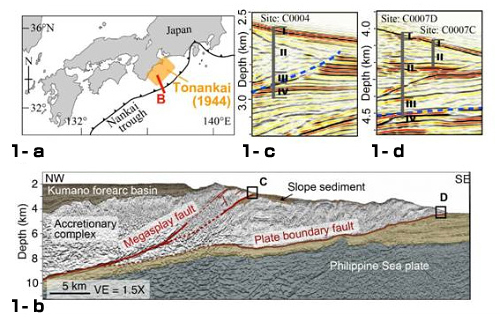
Figure 1.
1-a: In the Nankai Trough, off the southwestern coast of Japan, magnitude 8-class earthquakes have repeatedly occurred. The orange shaded area along the red line B in 1-a shows the source area of the 1944 Tonankai Earthquake. The NanTroSEIZE project is underway in this location.
1-b: Schematic diagram of the study area. Detailed seismic profiles illustrate the plate boundary fault and the megasplay fault. Coring was conducted at sites C and D.
1-c and 1-d: Enlarged images of the coring sites C and D, respectively. The vertical gray line shows the drill hole. The blue line denotes the megasplay fault in 1-c and the frontal thrust in 1-d, respectively. Cores were collected from these areas.
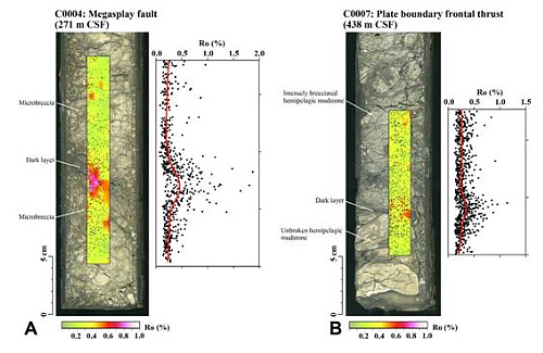
Figure 2. Measured vitrinite reflectance (Ro) distribution overlaid on photographs of slab core samples. CSFcore depth below seafloor.
A: Megasplay fault:
The megasplay fault consists of crushed rock about several tens of kilometers thick. Around halfway through this layer, at a depth of 27m blow seafloor, exists a layer of dark material. High reflectance (Ro) values were measured on vitrinite particles on the slab from this layer. These Ro values correspond to temperatures of about 400 degrees Celsius, implying the buildup of frictional heat at a high velocity slip.
B: Frontal thrust:
At the plate boundary frontal thrust, the dark layer exists at the bottom of the crushed rocks. The age of sediment beneath this layer is estimated to be 3.65 million years, younger than the overlaying sediment (5.32 million years). This suggests repeated activities of thrust over a long period of time. High vitrinite reflectance (Ro) values were measured on the slab surface as well, which correspond to temperatures of about 300 degrees Celsius.
In the photos above, black dots indicate particles with high Ro values.
Black dots denote Ro measurement points. The dark layer shows higher Ro values.
Contacts:
- Japan Agency for Marine-Earth Science and Technology
(For the study) - Arito Sakaguchi
Research Scientist, Solid Earth Dynamics Research Program
Institute for Research on Earth Evolution (IFREE)
Gaku Kimura
Professor, Earth and Planetary Science
School of Science, The University of Tokyo - (For publication)
- Hikaru Okutsu, e-mail: press@jamstec.go.jp
Senior Administrative Specialist, Planning Department Press Office
JAMSTEC
Hiromi Yokohama
Associate Professor, School of Science, The University of Tokyo