August 15, 2011
JAMSTEC
Photos from the 2011 Tohoku Earthquake Source Area
-Captured by Deep-Sea Submersible Shinkai 6500-
Overview
A series of photos taken by the JAMSTEC's deep-sea submersible Shinkai 6500 reveals the appearance of fissures and bacterial mats on the seafloor, which are possibly associated with the 2011 Earthquake of the Pacific Coast of Tohoku on March 11.
The survey was conducted from 30 June to 14 August, 2011 at three sites along the continental-side slope of the Japan Trench (Fig.1), to investigate biological, geochemical and geological impacts of the earthquake on the deep seafloor environments. The depth of the sites ranges from 3,200 to 5,350 meters.
The images taken by the submersible include:
1. Fissures and step-like topography on the seafloor (*1)
2. Methane seepage (*2) from the seafloor and the resulting colonization of bacteria (bacterial mats (*3))
3. Partial discoloration of the seafloor
4. Colonies of white giant clams, (Calyptogena phaseoliformis)(*4)
5. Dense habitation of sea cucumbers (Elpidiidae) (*5)
Scientists will do an in-depth analysis of the collected images and data to report the results.
JAMSTEC plan to continue surveys in this area to gain better insights into the mechanism and impacts of the earthquake.
*1. Seafloor fissures:
The fissures suggest crustal movement of the seafloor associated with a series of seismic activity during the March 11 earthquake.
*2. Methane seepage:
The seepage of groundwater containing dissolved methane is often observed along the seduction zone faults. In the surface sediment down to a depth of several centimeters, sulfate reducing bacteria form hydrogen sulfide from methane and sulfate ions. A high concentration of methane and hydrogen sulfide can therefore be supplied to fluids seeping from the seafloor.
*3. A bacteria mat is a dense assemblage of bacterial colonies, which stretches like a mat. Bacteria mats at the surveyed sites are considered to use reduction substances (e.g. methane and hydrogen sulfide ) as energy sources.
4. Calyptogena phaseoliformis
A white giant clam (15 cm long) living at depths of 4,700-6,400 meters along the Japan Trench and the KurilKamchatka Trench. The clams live in symbiosis with sulfur-oxidizing bacteria, and feed on organic matters produced by them. They occur in colonies and are specific to cold seeps and hydrothermal vents. The bivalve sticks its strong foot into the sediment and incorporate hydrogen sulfide to funnel it to the bacteria.
*5 Elipidiidae: a sea cucumber. Total length: 5-6cm. Elipidiid sea cucumber feed on the sediment surface.
Appendix1
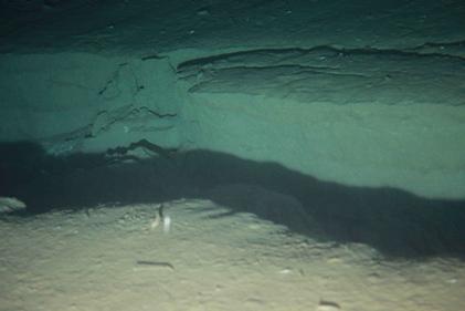
Photo 1. - Site 1 (water depth: 5351 m), Dive #1256, August 3, 2011
Onboard scientist: Hidetaka Nomaki, JAMSTEC
A fissure on the seafloor, approximately 1 meter deep and wide, runs from north to south for at least 80 meters. At the bottom of the fissure, lies the accumulation of dislodged sediment. No fissure of the seafloor was observed when the Shinkai 6500 dove at this site in 2006 (see the picture below). Scientists believe that the fissure were caused by the March 11 earthquake.
Reference Photo- Site 1(water depth: 5351 m), Dive#957, June 8, 2006
Onboard scientist; Xavier Prieto, Bremen University
The site has been surveyed several times in the past. Each time, the seafloor was covered by sediment, with many sea anemone thriving. No fissures were observed.
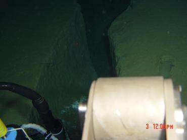
Photo2 - Site 1 (water depth: 5351 m), Dive #1256, August 3, 2011
Onboard scientist: Hidetaka Nomaki, JAMSTEC
Another photo of the fissure in Photo 1. The inner wall of the fissure is partially discolored. The fissure is observed above the geological fault, along which the pore waters containing dissolved methane often seep up. Bacterial mats are also shown in Photo 2 and 3 (white area), which thrive at methane rich seeps.
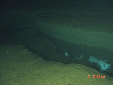
Photo 3- Site 1 (water depth: 5351 m), Dive #1256, August 3, 2011
Onboard scientist: Dr. Hidetaka Nomaki, JAMSTEC
The same fissures in Photo1 and 2 and bacterial mats (white area).

Photo 4 Site 2 (water depth: 3218 m), Dive #1259, August 10, 2011
Onboard scientist: Dr. Norio Miyamoto, JAMSTEC
The fissure runs through in a north-south direction. A 20 cm-wide crevasse stretches for at least tens of meters. Its bottom is too deep to fathom.
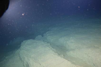
Photo 5 Site 2 (water depth: 3218 m), Dive #1259, August 10, 2011
Onboard scientist: Dr. Norio Miyamoto, JAMSTEC
Step-like topography with rises more than 1 meter in height. Slope failures are shown in some places.
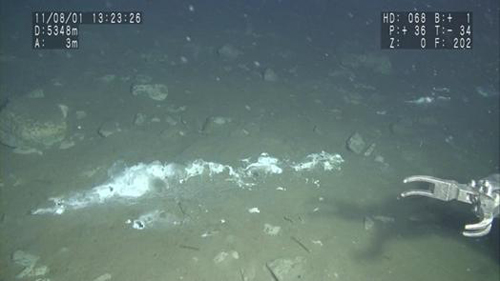
Photo 6 Site 1 (water depth: 5348 m), Dive #1254, August 1, 2011
Onboard scientist: Dr. Katsunori Fujikura, JAMSTEC
A bacterial mat formed at a seep on the seafloor (2 meters long). The overlying water emits the distinctively strong smell of hydrogen sulfide.
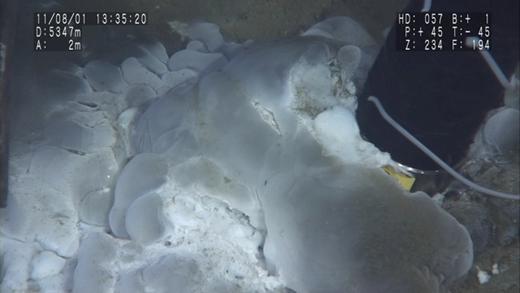
Photo 7Site 1 (water depth: 5349 m), Dive #1254, August 1, 2011.
Onboard scientist: Dr. Katsunori Fujikura, JAMSTEC
An enlarged image of the bacterial mat in Photo 6. Gelatinous masses probably associated with bacterial activities are observed.
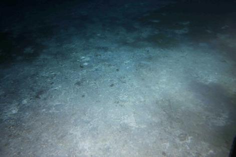
Photo 8 Site 1 (water depth: 5341 m), Dive #1255, August 2, 2011
Onboard scientist: Dr. Ken Tsuji, Kyoto University
A discolored area found at Site 1, which is assumed to be covered by a bacterial mat. The area covers approximately 20 m in both width and length.
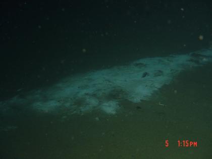
Photo 9Site 3 (water depth:3551 m), Dive #1257, August 5, 2011
Onboard scientist: Dr. Ken Takai, JAMSTEC
A white patch considered to be a bacterial mat. It is 5-6 meters long and 2-3 meters wide.
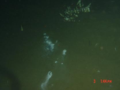
Photo 10- Site 1 (water depth: 5351 m), Dive #1256, August 3, 2011
Onboard scientist: Dr. Hidetaka Nomaki, JAMSTEC
Colonies of Calyptogena phaseoliformis and bacterial mats. The bivalve colonies had previously been confirmed and therefore survived the earthquake.
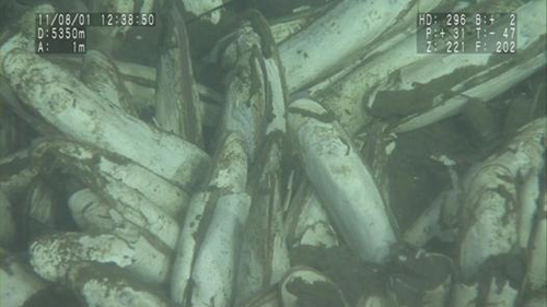
Photo 11Site 1 (water depth: 5350 m), Dive #1254, August 1, 2011.
Onboard scientist: Dr. Katsunori Fujikura, JAMSTEC
An enlarged image of Calyptogena phaseoliformis
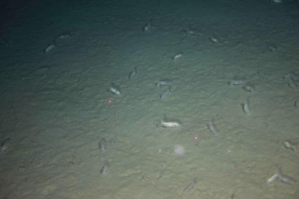
Photo 12- Site 1 (water depth: 5350 m), Dive #1256, August 3, 2011
Onboard scientist: Dr. Hidetaka Nomaki, JAMSTEC
An area densely populated with sea cucumbers. They were not found during the dive on June 8, 2006 (see the reference photo).
Appendix2
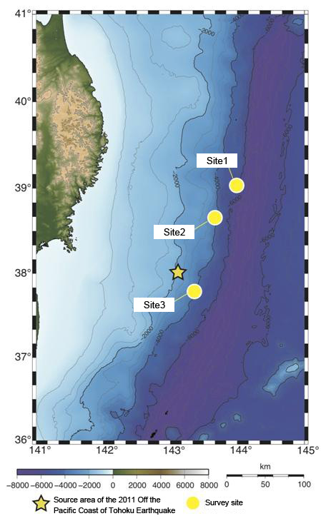
Figure 1:Survey Area
Site 1:39°07'N,143°53'E(water depth: 5,350m)
Site 2:38°39'N,143°36'E(water depth: 3,200m)
Site 3:37°45'N,143°17'E(water depth:3,500m)
Contacts:
- Japan Agency for Marine-Earth Science and Technology
(For the results) - Katsunori Fujikura
Team Leader, Marine Biodiversity Research Program
Institute of Biogeosciences (Biogeos) - (For publication)
- Hikaru Okutsu, e-mail: press@jamstec.go.jp
Senior Administrative Specialist, Planning Department Press Office