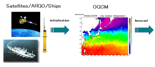
We have started an ocean weather forecast experiment December 2001 (FRSGC Press release, 2001) as a part of the Japan Coastal Ocean Predictability Experiment (JCOPE). The JCOPE has begun October 1997 under the initiative of the Frontier Research Center for Global Change (FRCGC), which is supported jointly by Japan Aerospace Exploration Agency (JAXA) and Japan Agency for Marine-Earth Science and Technology (JAMSTEC). The present JCOPE system has achieved near operational forecast using almost all available data obtained from satellites, ARGO floats and ships. The routine prediction of oceanic variation ("ocean weather forecast", Yamagata, 2002), combining with in-situ verification of the results, will significantly contribute to improve atmosphere-ocean models for prediction of longer-term climate change. Moreover, we have developed various kind of applications of our ocean weather forecast. Fisherier Reseach Agency (FRA) has operated first version of JCOPE ocean forecast system (JCOPE1; Miyazawa et al.,2008a; Kagimoto et al.,2008) since April 2007 for management of fishery resources off Japan through development of coupling with ecosystem models (FRA-JCOPE; Miyazawa et al., 2008b). JAMSTEC has further developed second version of the system (JCOPE2) with enhanced model and data assimilation schemes (Miyazawa et al., 2008b; 2009). JCOPE1 was mainly used to analyze the Kuroshio path variation south of Japan (Miyazawa et al.,2004;2005;2008a). We modified both the model and data assimilation schemes for better representation of the oceanic states especially in the Mixed Water Region. The output of JCOPE2 is used for ship routing of oil tankers, fishery and drilling ships. Recenly we have created new reanalysis data (FRA-JCOPE2) from 1993 to 2009 by assimilating huge amount of the in-situ data around Japan (Miyazawa et al., 2010).
Satellite altimeter data obtained for the last ten years show significant meso-scale activity south of Japan (Fig.1). Right panel of Fig.1 shows that a few month scale variation of sea surface height (SSH) has the same magnitude as the annual variation of that. Some studies clarified that this scale activity is due to the meso-scale eddies with a space scale of 100-500 km. Left panel of Fig.1 indicates that the meso-scale eddies dominate in both the Kuroshio and the subtropical front regions. A recent study using an innovative monitoring system shows that the Kuroshio path also varies with a few month time scale. Figure 2 plots time evolution of the distance from the coast of the Kuroshio path obtained from the inverted echo sounder across the ASUKA line. Each event of large distance from the coast corresponds to passing of the meander of the Kuroshio. Some meanders propagated to downstream region induce significant Kuroshio path variations east of the Kii Peninsula.
Now the real Kuroshio south of Japan takes the non-Large-Meander path. During the non-large meander period, the Kuroshio takes both the nearshore path and offshore path. Power spectra calculated from the Kuroshio path index caluculated from long-time sea level data indicates a few months scale variation (Figure 3). We define 'ocean weather' as a few month scale variations of the Kuroshio path and the meso-scale eddies.
Preliminary hindcast experiments of the Kuroshio path variation demonstrated that some short-term meanders south of Japan were induced by interactions between the Kuroshio and meso-scale eddies (Fig.4). Left half of Fig.4 shows transitions of the observed Kuroshio path. We initialized the model Kuroshio using the TOPEX/POSEIDON SSHA data. Then the model successfully predicted the meander after two months as shown in right half of Fig.4.
Limit of predictability of the Kuroshio meandering is suggested by an ensemble experiment of the 1999 event (Fig.5, Miyazawa et al., 2004). The ensemble experiment has shown that the forecasts rapidly bifurcate after 50 days. After 80days, three typical paths of the Kuroshio are generated in the ensemble. More forecast experiments must be performed to exactly determine limit of predictability of the Kuroshio path because it depends on patterns of path transitions.
The present ocean model is based on one of world community models, Princeton Ocean Model (POM/POMgcs) . A high-resolution, regional model with spatial grid of 1/12 degree and 45 sigma levels is embedded in a low-resolution basin-wide model with spatial grid of about 1/4 degree and 21 sigma levels (Fig.6). The former model domain covers the Northwest pacific (117E-180E, 12N-62N) and its lateral boundary condition is specified using the one-way nesting method (Guo et al., 2003) from the latter model. The low-resolution model underestimates the baroclinic component of the Kuroshio and overestimates its barotropic component. However, the high-resolution model corrects these defects and thus reproduces more realistic the density and current fields (Guo et al., 2003). Moreover, the present model reproduces three typical paths of the Kuroshio south of Japan as well as the meso-scale eddies (Fig.7, Miyazawa et al., 2002).
The model is driven by wind stresses, and heat and salt fluxes. The wind stress and heat flux field are calculated from the 6-hourly NCEP Global Forecast system data using the bulk formula (Kagimoto et al.,2008). The salinity at the surface is restored to the monthly mean climatology with a time scale of 30 days.
The high-resolution model assimilates three types of data: sea surface hight anomaly (SSHA) from NRL/SSC(Jason-1 and Geosat Follow On), sea surface temperature (SST) from NAVOCEANO MCSST , and temperature/salinity pfofiles (0m-400m) from GTSPP, which includes both the ARGO and ship data.
The model is forced by the climatological monthly wind stress and the heat/salt fluxes after the latest initialization. The short-term interaction between meso-scale eddies and the Kuroshio, which significantly influence the short-term Kuroshio path variation, is almost governed by variations of the main thermocline rather than the surface forcing at that time. In this system, two month forecast is executed every week starting from last Saturday.
The system has shown a forcasting skill of about one month during the real-time experiment in 2003 (Miyazawa and Yamagata, 2003). In particular, the system has successfully predicted a small meander propagating eastward along the Kuroshio south of Japan during March-May 2003 (Miyazawa, 2004).
FRSGC Press release, 2001: Experiments commenced for predicting oceanic variability near Japan
Guo, X., H. Hukuda, Y. Miyazawa and T. Yamagata, 2003: A triply nested ocean models -Roles of horizontal resolution on JEBAR-, J. Phys. Oceanogr. 33, 146-169. html
Kagimoto, T., Y. Miyazawa, X. Guo, and H. Kawajiri, 2008: High resolution Kuroshio forecast system -Description and its applications-, in High Resolution Numerical Modeling of the Atmosphere and Ocean, W. Ohfuchi and K. Hamilton (eds), Springer, New York, 209-234. html
Miyazawa, Y. and T., Yamagata, 2003:The JCOPE ocean forecast system (PDF), First Argo Science workshop, Tokyo, Japan, November 12-14 2003.
Miyazawa, Y., X. Guo and T. Yamagata, 2004: Roles of meso-scale eddies in the Kuroshio paths, J. Phys. Oceanogr. 34, 2203-2222. html
Miyazawa, Y, 2004: The JCOPE ocean forecast system , Frontier Newsletter, 24, 2-3.
Miyazawa, Y., S. Yamane, X. Guo and T. Yamagata, 2005: Ensemble forecast of the Kuroshio meandering, 2005: J. Geophys. Res., 110, C10026, doi:10.1029/2004JC002426. html
Miyazawa, Y., T. kagimoto, X. Guo, and H. Sakuma, 2008a: The Kuroshio large meander formation in 2004 analyzed by an eddy-resolving ocean forecast system, J. Geophys. Res.,113, C10015, doi:10.1029/2007JC004226. html
Miyazawa, Y., K. Komatsu, and T. Setou ,2008b: Nowcast skill of the JCOPE2 ocean forecast system in the Kuroshio-Oyashio mixed water region (in Japanese with English abstract and figure captions), J. Marine Meteorol. Society (Umi to Sora), 84, 85-91.
Miyazawa, Y., R. Zhang, X. Guo, H. Tamura, D. Ambe, J.-S. Lee, A. Okuno, H. Yoshinari, T. Setou, and K. Komatsu, 2009: Water mass variability in the western North Pacific detected in a 15-year eddy resolving ocean reanalysis, J. Oceanogr. 65, 737-756. html
Miyazawa, Y., X. Guo, R. Zhang, S.M. Varlamov, T. Watanabe, T. Setou, and D. Ambe, 2010: Roles of the in-situ observations in the detection of the Kuroshio frontal variability south of Japan, submitted.
JCOPE group, jcope at_mark jamstec.go.jp, Last updated: March 7, 2010.