
Super high-resolution simulation of observed 3D structures of the sea breeze front head by the Down-Scaling Simulation System(DS3)
The sea breeze has an important influence on the local weather and environment over the coastal areas. In particular, the passage of sea breeze front can bring a sudden change of winds, temperature, air quality, and even convective weathers. To date, however, it still remains a big challenge to realistically predict the detailed structures and progress of the sea breeze front over coastal city.
To realize the super high-resolution mesoscale forecast, we build a Down-Scaling Simulation System (DS3) that combines the parallelized CFD model developed by Tohoku University and the nested LETKF system of data assimilation on JMA-NHM developed by MRI. In this advanced system, the short-range forecast from mesoscale analyzed data is used to drive the building-resolving CFD model. Using K computer, we are now able to perform numerical experiment over a mesoscale domain of several ten kilometers with a super high resolution of several meters, such as for one whole city with individual buildings resolved. To evaluate the system performance, we apply DS3 to simulate a sea breeze front over Sendai Airport and compare numerical results with dual-Doppler lidar observations.
Figure 1 shows the 3D structures of a sea-breeze front observed by dual-Doppler lidar over Sendai Airport at 16 JST June 15, 2007. The aerosol is concentrated at the sea-breeze front and portrays the highly irregular features of the front head. Strong updrafts develop at the front head, while downdrafts are seen at the eastern rear of the front head. Following the front passage, surface observation reports a dramatic change of wind speed/direction and a decrease of temperature near the airport terminal. Figure 2 shows that the DS3 forecast of the temperature and winds over Sendai Airport. Compared with lidar observation, the numerical model is shown to reproduce well an inland progress of sea-breeze front and its fine-scale structures. The forecast field clearly presents the irregular features of front head, with several lobes/clefts at a scale of several hundred meters. The ambient warm flow from land ascends as strong updraft as it encounters front head, and then penetrates aloft. The cool air mass from marine side is also lifted at the front head but then falls back as downdraft, resulting to a high concentration of air pollutant at front head. The strongest overturns prefer to occur at the lobes of front head, associated with an active progress of gravity current.
In this study, it is the first time to realistically reproduce the 3D structures of sea-breeze front head over a mesoscale area at an unprecedented super high resolution. The results of this modeling provide insight into the dynamics of sea-breeze front and its significant impacts on the local weather/environment. It highlights the feasibility of a reliable prediction of sea breeze front that can be valuable for improving the weather forecast over coastal regions and the aviation safety over airport. With a building resolution over mesoscale area, this technology also has a potential to provide the improved forecast of wind and temperature within big city with many tall buildings in the future. Figure 3 shows another example of the temperature forecast near Sendai Station durning a typical sea breeze event. In the ongoing works, we will investigate more mesoscale weather cases and evaluate the forecast skill of numerical model at a very high resolution.
The detailed results of this study have been submitted to Monthly Weather Review (Chen et al., 2014a; 2014b).
Chen, G., X. Zhu, W. Sha, T. Iwasaki, H. Seko, K. Saito, H. Iwai, and S. Ishii, 2015: Toward Improved Forecasts of Sea-Br eeze Horizontal Convective Rolls at Super High Resolutions. Part I: Configur ation and Verification of a Down-Scaling Simulation System (DS3). Mon. Wea. Rev., 143, 1849-1872.
Chen, G., X. Zhu, W. Sha, T. Iwasaki, H. Seko, K. Saito, H. Iwai, and S. Ishii, 2015: Toward Improved Forecasts of Sea-Br eeze Horizontal Convective Rolls at Super High Resolutions. Part II: The Im pacts of Land Use and Buildings. Mon. Wea. Rev., 143, 1873-1894.
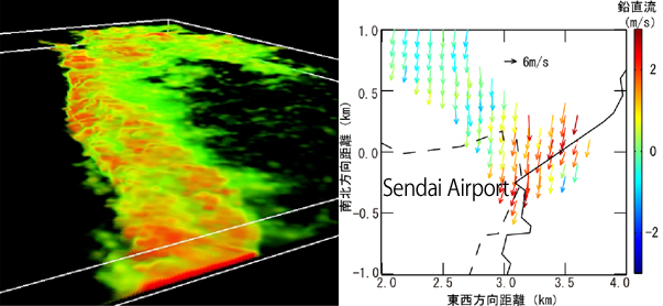
Figure 1. (a) Aerosol concentration (indicated by the SN ratio of lidar scan) observed over Sendai Airport at 16 JST June 15, 2007.
(b) Horizontal winds (vector) and vertical motion (color) at 200 m AGL retrieved by dual-Doppler lidar. The solid marks the sea-breeze front, and the dashed outlines the eastern boundary of airport runway.
(b) Horizontal winds (vector) and vertical motion (color) at 200 m AGL retrieved by dual-Doppler lidar. The solid marks the sea-breeze front, and the dashed outlines the eastern boundary of airport runway.
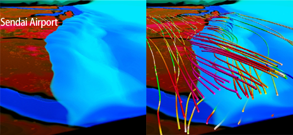
Figure 2. Temperature and air flows over Sendai airport simulated by DS3 in 10-min forecast valid at 16:10 JST, June 16, 2007. The colorful background shows the ground temperature. The isothermal surface denotes the air temperature of 294 K. The stream line in red (blue) denotes a rising (sinking) motion.

Figure 3. Temperature perturbations near Sendai station simulated by DS3 during a sea breeze event at 13 JST June 19, 2007.
Contact
Corresponding to Guixing Chen and Weiming Sha (Tohoku University)
and Kazuo Saito (Meteorological Research Institute/JAMSTEC)
Email:

Corresponding to Guixing Chen and Weiming Sha (Tohoku University)
and Kazuo Saito (Meteorological Research Institute/JAMSTEC)
Email: