
The Japanese cherry trees have started blossoming in central Tokyo, and, according to the Japanese Meteorological Agency (JMA), this was 5 days earlier than average. Full blossom was expected about a week later but, due to the recent cold snap, it seems this will be delayed.
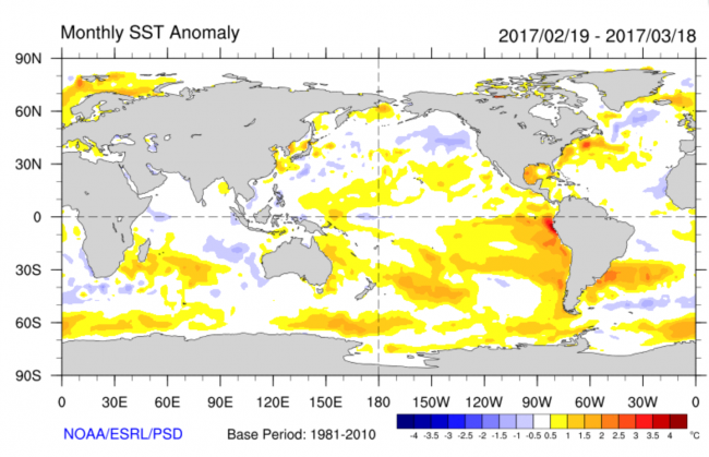
In this post we want to discuss the recent torrential rainfall and floods in Peru (see e.g. here). These heavy rains were likely influenced by the unusually warm sea-surface temperatures (SSTs) off the coast of Peru, which helped to destabilize the atmosphere. Figure 1 shows SST anomalies (how much the SST differed from the long-term average) for a recent 30-day period. Areas in yellow and red are where the temperatures were warmer than average. Off Peru, SST anomalies exceed 3 ºC, more than anywhere else on the globe.

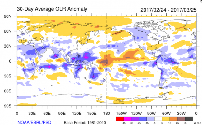
In the tropics, an increase in SST is usually accompanied by upward atmospheric motion (convection), which leads to storm clouds (cumulonimbus) and rain. Figure 2 shows outgoing longwave radiation (OLR), which is a measure of storm cloud occurrence (when storm clouds are present, they prevent infrared radiation from escaping to space; thus storm clouds show up as areas of reduced OLR). The averaging period is similar to that of Fig. 1, and anomalies of OLR are shown. The blue and purple show areas of deep convection and heavy precipitation. Increased rainfall over coastal Peru and its off-shore region is visible in Figure 2.
Last winter saw the occurrence of a La Niña Modoki. This kind of climate event is marked by warm SST anomalies in the western tropical Pacific, cool SST anomalies in the central Pacific around the international dateline, and warm SST anomalies in the far eastern Pacific, including off the coast of Peru. This pattern was also discussed in our recent post on forecast verification. Around the beginning of the year, SSTs started warming up rapidly off the coast of Peru and spread westward. There is a chance that these temperature anomalies will further develop into a full-fledged El Niño event. The APL SINTEX-F forecast from January 2017 does indeed predict an El Niño event to develop by this summer. This is backed up by the most recent forecast from March, which still predicts El Niño to occur. Apart from the local impacts of this event, it seems that it might also influence remote areas, such as Japan, where a number of low pressure systems brought heavy snowfall. Since there is also an Indian Ocean Dipole event predicted to develop, we can expect a number of unusual weather patterns this summer. We will keep a close eye on the situation.