


Seems like Japan is getting its fair share of typhoons this year. But even when there is no typhoon around it tends to rain a lot. The photo above shows the Sugita River just before the approach of typhoon #16 (aka Malakas outside Japan). It might be difficult to appreciate from the photo but take our word for it: the water level is a lot higher than the usual few inches. So what is the further outlook for fall? According to the SINTEX-F prediction most areas around the globe will see warmer than average surface temperatures. The tropical Pacific will be marked by weak La Niña or La Niña Modoki conditions, while in the Indian Ocean the negative Indian Ocean Dipole (IOD) will reach its peak. The influence of this configuration on regional rainfall will be discussed below.
Air temperature and rain forecast for the period September through November
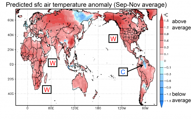
Warmer than average temperatures are expected in many areas of the world (Fig. 1). One of the few exceptions is northern Brazil.
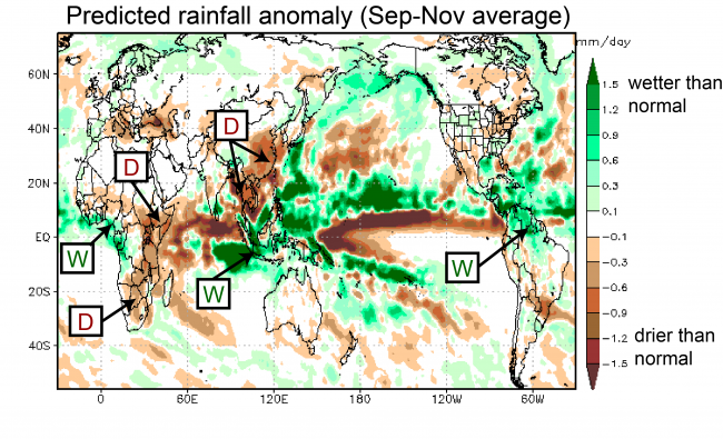
The SINTEX-F prediction indicates drier than normal conditions over eastern China, Mainland Southeast Asia, and eastern and southern Africa. Above average rainfall is expected over Indonesia, tropical South America, and parts of western and central Africa, among others.
As for Japan, the period September through November is forecast to be warmer than usual. Rainfall is predicted to be above average over western Japan. Please keep in mind, however, that forecast accuracy for mid and high latitudes is limited.
Ocean temperatures for the period September through November
In difference to daily weather fluctuations, seasonal climate variations are strongly influenced by changes in sea-surface temperatures (SSTs). Particularly in the tropics, where the SSTs are warmer than in other regions, even small changes in temperature can produce far reaching effects.
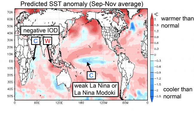
According to the SINTEX-F predictions, weak La Niña or La Niña Modoki conditions in the central tropical Pacific will reach their peak during fall (Fig. 3). In the Indian Ocean, the negative phase of the IOD is expected to reach its peak in fall. This likely contributes to the forecast of drier than normal conditions over East Africa and wetter than normal conditions over Mainland Southeast Asia.
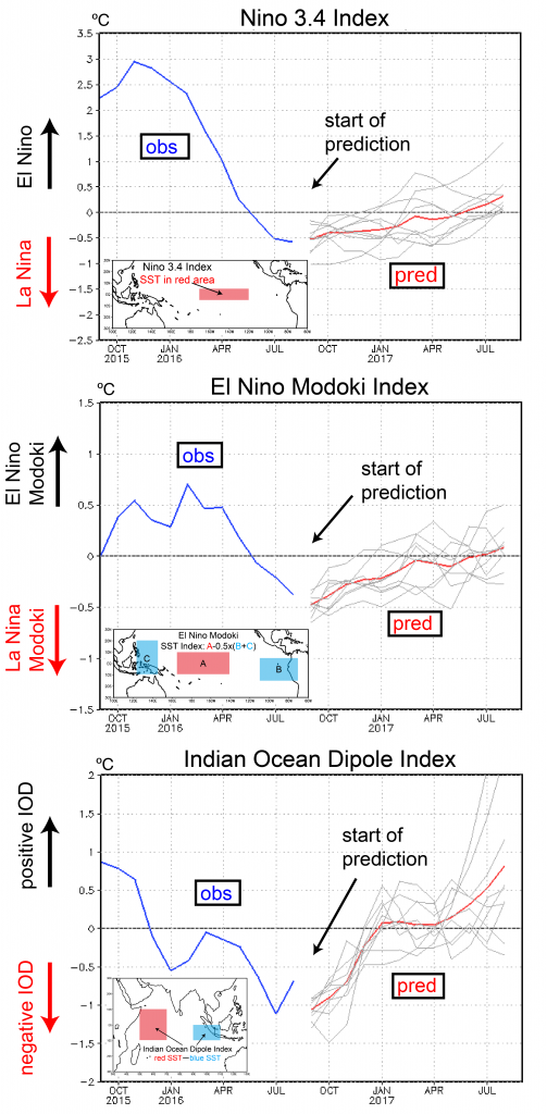
Finally, let’s look at how conditions in the tropics will develop over the coming 12-month period. Figure 4 shows three indices that characterize the state of the tropical Pacific and Indian Ocean. Both the Niño 3.4 and Modoki indices are predicted to stay slightly below zero for the remainder of the year, indicating weak La Niña or La Niña Modoki conditions. Next spring, conditions will return to neutral.
The IOD index is expected to reach its peak in September and gradually return to neutral by January of next year. Temperatures are predicted to stay below -0.5 ºC from September through November, indicating that the negative IOD will last through fall.
It remains to be seen how the combination of a weak La Niña (or La Niña Modoki) and a negative IOD will influence climate across the globe in the coming months.